I’ve been focused on really large scale urban landscapes a lot recently. I’ve had some fantastic final year project students this year who have used different approaches to addressing large-scale issues. For example, final year student Jonathan Emery @JonnyEmery31 integrated health into assessments of where new urban growth could and should happen in the Sherwood Forest area. Jonny wants to develop the landscape planning approach to urban-rural fringe development beyond landscape sensitivity and capacity studies with the aim of achieving a more sustainable model of urban growth and build healthier communities.
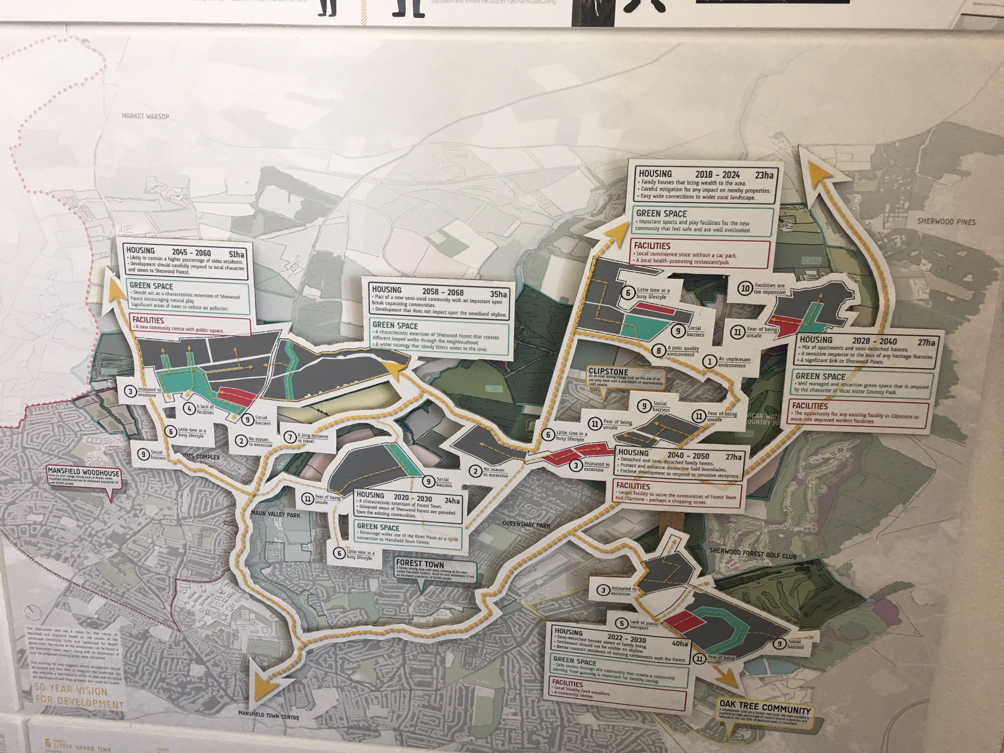
Jonny's map shows future changes to the Sherwood Forest area if we took the health of residents into account when planning urban development.

Some of Jonny's analysis of health issues at the large scale
Here in Sheffield, Masters student Nafsika Michail @nafsika_michail took a highly creative approach to river valley planning which was focused on wellbeing and how the city better connected by using the blue infrastructure. Her highly contextual study which focused on the Upper Don Valley river corridor. She was particularly attentive to (among other things) the weak connections between the existing valuable green spaces. Nafsika concluded that these green spaces (including Parkwood Springs, Wardsend Cemetery and the nearby Ponderosa, Hillsborough and Middlewood Parks, if you know the area) – are all great places but for Sheffield readers, when was the last time you visited more than one of these?

Some of Nafsika's sketches of the Upper Don Valley in Sheffield

This year, I challenged my 2nd year undergraduate students to look at part of the Upper Don Valley river corridor that Nafsika was looking at, specifically between Kelham Island and Hillsborough. There are some huge changes going on down there with lots of new housing springing up but much of it without adequate green space provision. Students highlighted how under-utilised the river is and how much potential there is for a green corridor which is a safe alternative for pedestrians and cyclists from the busy ring road.
Thinking at the planning scale has been hard for all of these students. It requires a shift in focus from what we can see immediately around us to thinking about land uses (housing, woodland, commercial), and how they change over time and the effects this all has on neighbourhoods, town and cities, and wider regions. The ongoing development in Kelham Island, downstream has an impact on who will use Parkwood Springs in the future further up the valley. What if that once-a-day train was re-routed off the nearby Stocksbridge trainline and replaced by a tram connection or a walking/ cycle route?

2nd year undergraduate Wing Yuen's analysis of green space in the area

Part of 2nd year undergraduate Amber Norman's 20-year strategy for the Upper Don Valley
Thinking at the this large planning scale allows us to explore different ways of planning significant urban landscape change and what happens today and in the future. This is big place-keeping in action!!

2nd year undergraduate Emma Beaumont's public transport strategy